Collier Ships are back on the Horizon
Coal is back. According to the US Energy Information Administration, coal exports are projected to climb to 83.8 million st (short ton) in 2021, up from the four-year low of 69.1 million st in 2020. Exports are expected to increase again in 2022 to 99.1 million st.
Thermal coal export volumes are estimated at 36.9 million st in 2021 and 41.7 million st in 2022, up from 27 million st in 2020. The EIA said it assumes the “seaborne steam coal market in 2021 will be more robust with higher demand for US coal.”
Hampton Roads, particularly Newport News is the nation’s largest coal exporting port. Dominion Terminal, also known as the DTA Terminal, is the coal export terminal for this area. CSX Transportation delivers unit trains from Eastern coal mines. Fast transit times from the mines to the terminal, combined with a ground storage capacity of 1.7 million tons combine to minimize the total time in port for vessels. However, the demand is high, and so is the wait.
All the collier ships anchored off of Cape Charles are waiting to be loaded with mixed coal from DTA.
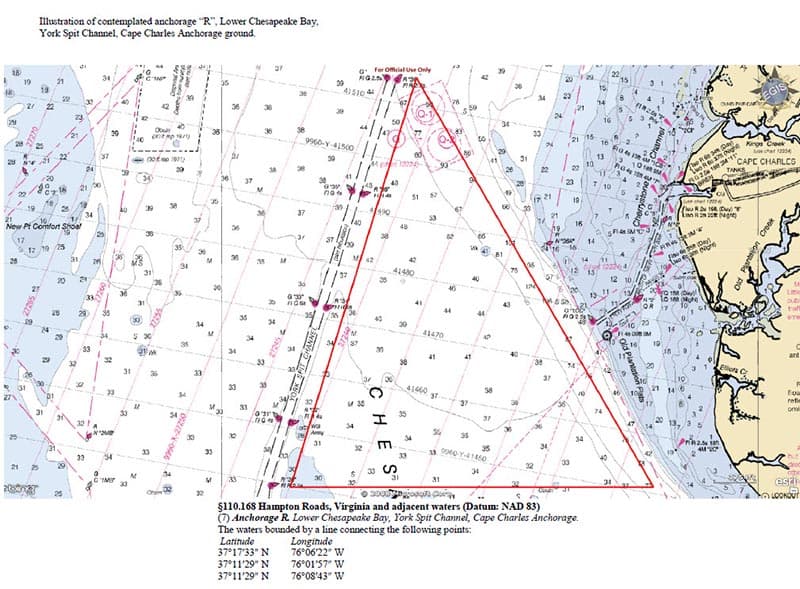
The Coast Guard has established the commercial anchorage ground, Anchorage R, approximately 3 nautical miles (NM) west of Cape Charles, VA. The USCG increased the size and of the previous, temporary quarantine anchorage.
The 7.9 NM long eastern boundary of Anchorage R is located generally 3 NM west of Cape Charles, VA. The southernmost boundary is 3.9 NM long and runs parallel with and 500 yards north of the existing Regulated Navigation Area.The western boundary of the anchorage grounds runs parallel along, and no less than 500 yards east of York Spit Channel for 13.9 NM, including an 11.2 NM length between Lighted Buoys 24 and 38 and then continuing northeast for 2.7 NM beyond Lighted Buoy 38. The anchorage is 0.6 NM long at its northern boundary.

The Coast Guard is moving the existing Quarantine Anchorage (Anchorage Q), from the current location 3.5 NM to the west of Cape Charles, VA, and east of York Spit Channel between Lighted Buoys 36 to 38, relocating it 6 NM southwest of Fishermans Point, VA. The new location runs 625 yards west of York Spit Channel between buoys 16 and 18. The eastern boundary of Anchorage Q runs parallel to York Spit Channel for 2.2 NM. The southernmost boundary is 1.3 NM from the emergency restricted area outside the Chesapeake Bay Bridge-Tunnel. The westernmost boundary is 2.2 NM. The northernmost boundary is 450 yards southwest of York River Entrance Channel and runs for 1.3 NM. Its size is increasing from approximately 1.1 to 1.7 square miles
The final rule on Anchorage R can be read here.
View article here.
- On September 9, 2021
